
iGUIDE For Insurance Claims
And Restoration Projects
SAVE TIME AND CUT COSTS
Picture Your Listings™ iGUIDE camera system rapidly captures and shares accurate LIDAR point cloud data measurements and 360° images for insurance claims loss consultants and restoration projects.
We capture all of the data required for an iGUIDE in one visit. An average 3,000 sq. ft. building can be captured in under 15 minutes. We minimize disruption to property owners and we focus on what matters to them and their business.

TWO iGUIDE SOLUTIONS FOR INSURANCE CLAIMS
Insurance claims loss consultants and restoration professionals now have accurate, rapid, and efficient solutions to capture and share comprehensive property data for estimating damages costs.
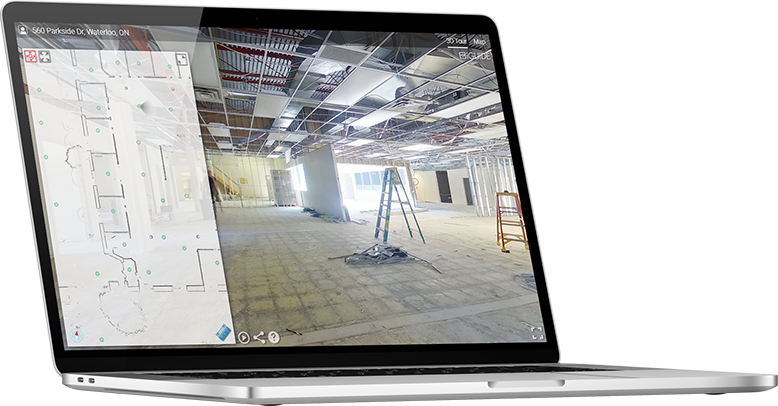
iGUIDE Radix
The fastest way to document a loss. Capture a loss in minutes, upload your data from the site, and get access to the images and measurements instantly to estimate remotely:
You can immediately publish this data online and then share it to begin the estimating process, or further edit it before uploading. When uploaded to the iGUIDE cloud, 3D visual tours and DXF files are automatically generated.
The DXF files will contain all of the 2D point cloud data for use in AutoCAD™ or compatible software. Measurements can be made on the 3D visual tour itself and exported in a JPEG file. Import a scaled JPEG file into Xactimate™, Symbility™, or other claim management software as an underlay for rapid floor plan sketching. Or, upload your data to Planitar and have a complete floor plan drafted for you as a standard or premium iGUIDE. As with all iGUIDEs, Radix can be downloaded as a standalone ZIP file for archival purposes, offline viewing, or hosting on a 3rd-party online claim management cloud.
iGUIDE Standard or iGUIDE Premium
Comprehensively document a loss with all of the DXF 2D point cloud data and get professionally-drafted floor plans, room measurements, and square footage totals with iGUIDE Standard or iGUIDE Premium.
The Advantage Of iGUIDE For Insurance Claims
The cutting-edge advantage relied upon by adjusters, estimators, renovators, inspectors, managers, designers, developers, and property owners to accurately document and showcase any property space.
iGUIDE Radix takes insurance claims and restoration professionals to a higher level of speed, accuracy and reliability.
Why iGuide For Insurance Claims?
-
Save Time
Easily capture and share data rapidly.
Estimate remotely.
Make faster decisions.
-
Cut Costs
Eliminate multiple site visits.
No subscriptions.
Reduce labor costs.
Cut travel costs.
Billed for only what you need.
-
Convenience
Compatible with estimating software.
Export point cloud as DXF for CAD software.
-
Accurate Data
Lidar-accurate measurements.
Calculate replacement costs.
Document as-is condition of loss.
-
Own Your Data
Access and download the complete Radix tour with all assets for archiving.
View data offline.
Self-host data on your server.